[{"id":428501205306,"handle":"entire-print-collection","title":"Entire Print Collection","updated_at":"2023-09-20T13:30:43+10:00","body_html":"Welcome to Antiquarian Print Shops Entire Print Collection. We have rare antique prints covering a wide variety of topics and artists. These includes Botanicals, Maps, Animals, Birds, Insects, Australia and works from Sylviester Diggles, William Curtis, John Tallis and more. Enjoy!","published_at":"2022-11-22T13:42:49+10:00","sort_order":"alpha-asc","template_suffix":"","disjunctive":false,"rules":[{"column":"variant_price","relation":"less_than","condition":"10000"},{"column":"type","relation":"not_contains","condition":"Gift Cards"},{"column":"vendor","relation":"not_contains","condition":"Printify"}],"published_scope":"global","image":{"created_at":"2023-09-06T10:08:34+10:00","alt":null,"width":1080,"height":1080,"src":"\/\/antiquarianprintshop.com\/cdn\/shop\/collections\/Antiquarian_Prints_-_Collections_6.png?v=1693958915"}},{"id":58302103638,"handle":"maps","title":"Maps Collection","updated_at":"2023-09-06T11:04:27+10:00","body_html":"\u003cp\u003eF\u003c\/p\u003e\n\u003cp\u003e\u003cspan style=\"font-weight: 400;\"\u003eThese \u003c\/span\u003e\u003cspan style=\"font-weight: 400;\"\u003eantique map prints\u003c\/span\u003e\u003cspan style=\"font-weight: 400;\"\u003e have been carefully selected for their historical and artistic value. This Maps Collection is\u003c\/span\u003e\u003cspan style=\"font-weight: 400;\"\u003e not only beautiful but a valuable piece of history.\u003c\/span\u003e\u003c\/p\u003e\n\u003cp\u003e \u003c\/p\u003e","published_at":"2018-10-13T13:13:19+10:00","sort_order":"alpha-asc","template_suffix":"","disjunctive":true,"rules":[{"column":"tag","relation":"equals","condition":"Maps"},{"column":"title","relation":"contains","condition":"Maps"}],"published_scope":"global","image":{"created_at":"2018-10-14T17:34:21+10:00","alt":"","width":1080,"height":1080,"src":"\/\/antiquarianprintshop.com\/cdn\/shop\/collections\/IMG_2107.jpg?v=1693893595"}},{"id":459076534586,"handle":"under-400","title":"Prints Under $400","updated_at":"2023-09-20T13:30:43+10:00","body_html":"\u003cspan data-mce-fragment=\"1\"\u003eA selection of a\u003c\/span\u003e\u003cspan data-mce-fragment=\"1\"\u003entique prints from our Collections for under $400! Covering many topics from Botanicals to Architecture. Explore now!\u003c\/span\u003e","published_at":"2023-09-06T13:08:58+10:00","sort_order":"best-selling","template_suffix":"","disjunctive":false,"rules":[{"column":"variant_price","relation":"less_than","condition":"400"}],"published_scope":"global","image":{"created_at":"2023-09-06T13:08:57+10:00","alt":null,"width":1080,"height":1080,"src":"\/\/antiquarianprintshop.com\/cdn\/shop\/collections\/Prints_Under_400.png?v=1693969737"}},{"id":174431895638,"handle":"tallis-map-of-victoria","title":"Tallis Map Collection","updated_at":"2023-09-20T12:11:59+10:00","body_html":"\u003cdiv\u003e\n\u003cdiv class=\"\"\u003e\n\u003cdiv id=\":ok\" class=\"ii gt\"\u003e\n\u003cdiv class=\"a3s aXjCH\"\u003e\n\u003cdiv class=\"a3s aXjCH\"\u003e\u003c\/div\u003e\n\u003c\/div\u003e\n\u003cdiv class=\"a3s aXjCH\"\u003eOur collection of antique map prints from John Tallis are highly sought. John Tallis and Company published maps and Atlases in London from roughly 1838 to 1851. His principal engraver was John Rapkin, whose name and decorative vignettes appear on most Tallis \u0026amp; Co. maps. Due to the decorative style of Rapkin's work, many regard Tallis maps as the last bastion of English decorative cartography in the 19th century.\u003cbr\u003e\n\u003c\/div\u003e\n\u003c\/div\u003e\n\u003c\/div\u003e\n\u003c\/div\u003e\n\u003cdiv\u003e\u003cbr\u003e\u003c\/div\u003e\n\u003cdiv\u003e\u003c\/div\u003e\n\u003cdiv\u003eAny history buffs with an interest in maps will love this collection.\u003cbr\u003e\n\u003c\/div\u003e\n\u003cdiv\u003e\u003c\/div\u003e","published_at":"2020-12-08T09:25:03+10:00","sort_order":"best-selling","template_suffix":"","disjunctive":false,"rules":[{"column":"title","relation":"contains","condition":"tallis"}],"published_scope":"global","image":{"created_at":"2020-12-08T09:25:02+10:00","alt":null,"width":1080,"height":1080,"src":"\/\/antiquarianprintshop.com\/cdn\/shop\/collections\/IMG_2092_1024x1024_2x_2cab7670-256d-401b-bee9-fa7ec5aafcde.jpg?v=1694051783"}}]
Technique: steel engraving, original antique uncoloured
Price: $350
Description:
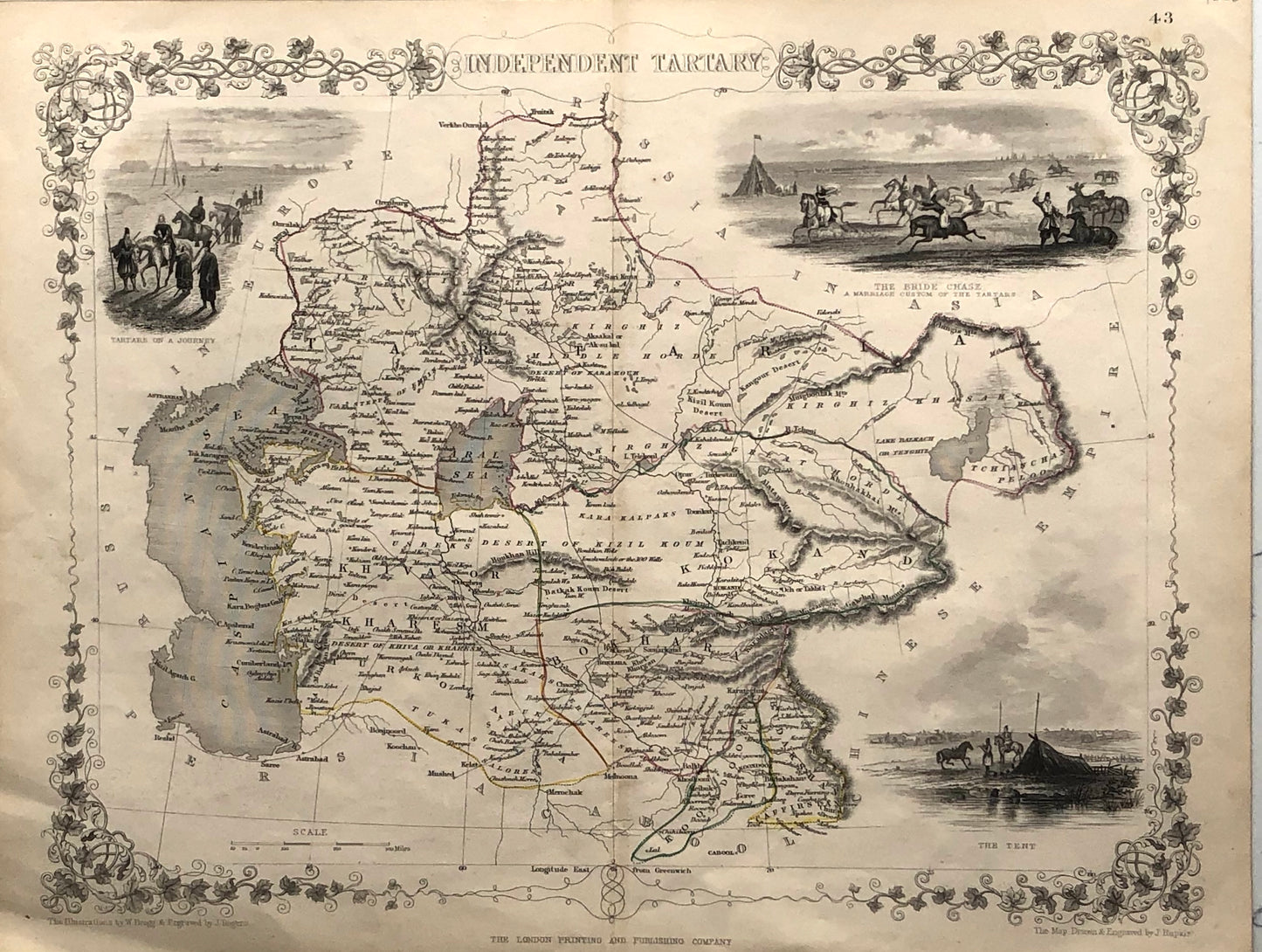
This is a highly decorative 1851 map of Independent Tartary by John Tallis and John Rapkin. It covers the regions between the Caspian Sea and Lake Bakquash and between Russia and Afghanistan. These include the ancient Silk Route kingdoms of Khiva, Tartaria, Kokand, and Bokhara. Today this region roughly includes Kazakhstan, Uzbekistan, Turkmenistan, Kyrgyzstan, and Tajikistan. This wonderful map offers a wealth of detail for anyone with an interest in the Central Asian portion of the ancient Silk Road. Identifies various caravan routes, deserts, wells, and stopping points, including the cities of Bokhara and Samarkand. Three vignettes by W. Bragg decorate the map, these including an image of Tartars on a Journey, a horseback Bride Chase, and a tartar campsite. Surrounded by a vine motif border. Engraved by J. Rapkin for John Tallis's 1851Illustrated Atlas.
Biography:
CARTOGRAPHER
John Tallis and Company published views, maps and Atlases in London from roughly 1838 to 1851. The principal works, expanding upon the earlier works of Cary and Arrowsmith, include an 1838 collection ofLondon Street Viewsand the 1849Illustrated Atlas of the World. His principal engraver was John Rapkin, whose name and decorative vignettes appear on most Tallis & Co. maps. Due to the decorative style of Rapkin's work, many regard Tallis maps as the last bastion of English decorative cartography in the 19th century. Though most Tallis maps were originally issued uncolored, it was not uncommon for 19th century libraries to commission colorists to "complete" the atlas. The London Printing and publishing Company of London and New York bought the rights for many Tallis maps in 1850 and continued Publishing hisIllustrated Atlas of the Worlduntil the mid 1850s. Specific Tallis maps later appeared in innumerable mid to late 19th century publications as illustrations and appendices.
SOURCE
Tallis, J.,The Illustrated Atlas, And Modern History Of The World Geographical, Political, Commercial & Statistical, 1851.