Map | Steiler Adolf | Steilers Hand Atlas Map, Africa ,Gotha 1840
[{"id":428501205306,"handle":"entire-print-collection","title":"Entire Print Collection","updated_at":"2023-05-30T09:25:57+10:00","body_html":"","published_at":"2022-11-22T13:42:49+10:00","sort_order":"alpha-asc","template_suffix":"","disjunctive":false,"rules":[{"column":"variant_price","relation":"less_than","condition":"10000"},{"column":"type","relation":"not_contains","condition":"Gift Cards"},{"column":"vendor","relation":"not_contains","condition":"Printify"}],"published_scope":"global"},{"id":58302103638,"handle":"maps","title":"Map Print Collection","updated_at":"2023-05-23T14:08:22+10:00","body_html":"\u003cp\u003eFrom the journeys of early Roman explorers, man has been mapping the Earth to allow others to follow their paths. Explorers like James Cook, Mathew Flinders and William Dampier relied on the cartographers to steadily map their courses and document their discoveries.\u003c\/p\u003e\n\u003cp\u003e\u003cspan style=\"font-weight: 400;\"\u003eThese \u003c\/span\u003e\u003cspan style=\"font-weight: 400;\"\u003eantique map prints\u003c\/span\u003e\u003cspan style=\"font-weight: 400;\"\u003e have been carefully selected for their historical and artistic value. Each of our \u003c\/span\u003e\u003cspan style=\"font-weight: 400;\"\u003eantique prints and maps\u003c\/span\u003e\u003cspan style=\"font-weight: 400;\"\u003e are not only beautiful but a valuable piece of history.\u003c\/span\u003e\u003c\/p\u003e\n\u003cp\u003e\u003cspan style=\"font-weight: 400;\"\u003eOur antique map shop\u003c\/span\u003e\u003cspan style=\"font-weight: 400;\"\u003e holds a beautiful selection of prints. From detailed depictions of cities and landmarks to maps that charted the world's greatest oceans. Whether you're a seasoned collector or a newcomer to the world of antique prints and maps, we are confident you will find something that speaks to you.\u003c\/span\u003e\u003c\/p\u003e","published_at":"2018-10-13T13:13:19+10:00","sort_order":"alpha-asc","template_suffix":"","disjunctive":true,"rules":[{"column":"tag","relation":"equals","condition":"Maps"},{"column":"title","relation":"contains","condition":"Maps"}],"published_scope":"global","image":{"created_at":"2018-10-14T17:34:21+10:00","alt":"","width":1080,"height":1080,"src":"https:\/\/cdn.shopify.com\/s\/files\/1\/1617\/1641\/collections\/IMG_2107.jpg?v=1661380119"}},{"id":428112281914,"handle":"under-400","title":"Prints Under $400","updated_at":"2023-05-30T09:25:57+10:00","body_html":"Prints under $400.","published_at":"2022-11-17T14:13:11+10:00","sort_order":"alpha-asc","template_suffix":"","disjunctive":false,"rules":[{"column":"variant_price","relation":"less_than","condition":"400"},{"column":"vendor","relation":"not_contains","condition":"Printify"}],"published_scope":"global"},{"id":263356317782,"handle":"steiler-adolf-collection","title":"Steiler, Adolf Collection","updated_at":"2023-03-20T22:47:36+10:00","body_html":"","published_at":"2022-01-18T12:32:09+10:00","sort_order":"best-selling","template_suffix":"","disjunctive":false,"rules":[{"column":"title","relation":"contains","condition":"Steiler Adolf"}],"published_scope":"global","image":{"created_at":"2022-01-18T12:34:06+10:00","alt":null,"width":1657,"height":1657,"src":"https:\/\/cdn.shopify.com\/s\/files\/1\/1617\/1641\/collections\/Steiler_Adolf.jpg?v=1642473247"}}]
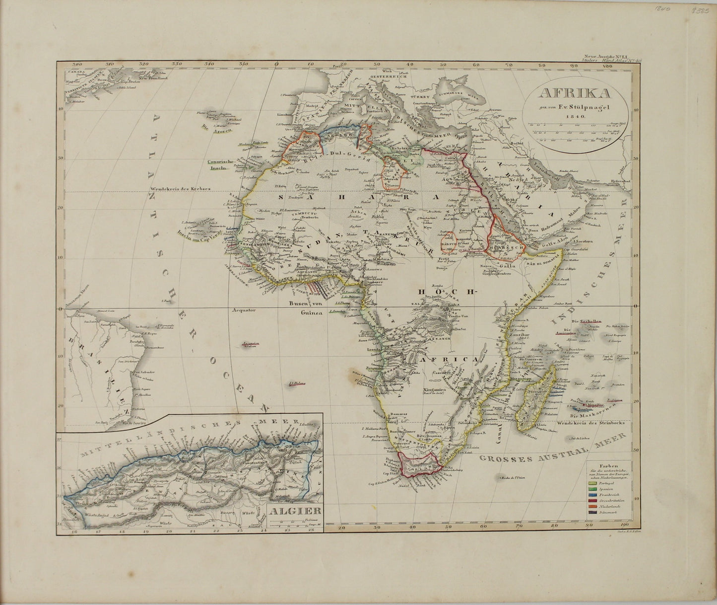
Map, Steiler Adolf, Afrika, Steilers Hand Atlas,1840
Regular price
$300.00
Sale
Steilers Hand Atlas Map, Africa ,Gotha
Date: 1840
Artist: Steiler Adolf
Engraver: Stulpnagel FV
Printer: Adolf Stieler
Image Size: 330 x 440mm
Paper size: 370 x 445mm
Condition: Very Good
Technique: Steel Engraving
Publisher: Gotha: Justus Perthes
Price: $300
Description: Original Steel Engraving, later hand coloured. Published in Germany for tielers Hand Atlas. This is a rare historical cartographic image
Engraver or Printer: Stieler Adolf
Published In: Hand Atlas Uber Alle Theile Der Erde Und Uber Das Weltgebaude. Herausgegeben Von Adolf Steiler. Gotha Justus Perthes.
Publication Author: Steiler, Adolf
Publication Date: 1839
Publication Note: Stieler's Atlas is extraordinarily detailed. Close examination of the maps shows many features that one would expect to find only on much larger maps. This atlas was first published in 1817, with editions continuing well into the 20th century. It was one of the most comprehensive and best executed 19th century German atlases. In this edition, the maps are dated 1839. Atlas is bound in half leather brown cloth covered boards with "Steiler's Hand Atlas" stamped in gilt on the front cover and spine. Maps are both hand painted and printed in full and outline colour.