Map, Tallis John, Western Australia Swan River | Antiquarian Print Shop
[{"id":156584476758,"handle":"australia","title":"Australia Collection","updated_at":"2023-09-27T11:08:32+10:00","body_html":"\u003cp\u003eThis Australian Collection of rare antique prints is made up from an array of prints from the 19th Century.\u003c\/p\u003e\n\u003cp\u003eThese include buildings, landscapes and native animals. Any enthusiasts of early settlement of Australia will be fascinated by the stories in these prints.\u003c\/p\u003e\n\u003cp\u003eA highly recommended collection of prints.\u003c\/p\u003e","published_at":"2019-11-27T13:28:45+10:00","sort_order":"created-desc","template_suffix":"","disjunctive":false,"rules":[{"column":"title","relation":"contains","condition":"Australia"}],"published_scope":"global","image":{"created_at":"2021-09-10T15:40:35+10:00","alt":null,"width":1080,"height":1080,"src":"\/\/antiquarianprintshop.com\/cdn\/shop\/collections\/Australia.jpg?v=1693892987"}},{"id":263180517462,"handle":"australian-maps","title":"Australian Maps Collection","updated_at":"2023-09-05T15:48:31+10:00","body_html":"\u003cp data-mce-fragment=\"1\"\u003eJohn Tallis is a well renowned British cartographer, map maker and publisher. These works of Australian Maps are some of the finest from the 19\u003csup data-mce-fragment=\"1\"\u003eth\u003c\/sup\u003e Century.\u003c\/p\u003e","published_at":"2021-12-17T12:35:50+10:00","sort_order":"alpha-asc","template_suffix":"","disjunctive":false,"rules":[{"column":"tag","relation":"equals","condition":"Australian Maps"}],"published_scope":"global","image":{"created_at":"2021-12-17T13:02:00+10:00","alt":null,"width":1080,"height":1080,"src":"\/\/antiquarianprintshop.com\/cdn\/shop\/collections\/Australian_Maps.png?v=1693892911"}},{"id":428501205306,"handle":"entire-print-collection","title":"Entire Print Collection","updated_at":"2023-09-28T09:20:01+10:00","body_html":"Welcome to Antiquarian Print Shops Entire Print Collection. We have rare antique prints covering a wide variety of topics and artists. These includes Botanicals, Maps, Animals, Birds, Insects, Australia and works from Sylviester Diggles, William Curtis, John Tallis and more. Enjoy!","published_at":"2022-11-22T13:42:49+10:00","sort_order":"alpha-asc","template_suffix":"","disjunctive":false,"rules":[{"column":"variant_price","relation":"less_than","condition":"10000"},{"column":"type","relation":"not_contains","condition":"Gift Cards"},{"column":"vendor","relation":"not_contains","condition":"Printify"}],"published_scope":"global","image":{"created_at":"2023-09-06T10:08:34+10:00","alt":null,"width":1080,"height":1080,"src":"\/\/antiquarianprintshop.com\/cdn\/shop\/collections\/Antiquarian_Prints_-_Collections_6.png?v=1693958915"}},{"id":58302103638,"handle":"maps","title":"Maps Collection","updated_at":"2023-09-06T11:04:27+10:00","body_html":"\u003cp\u003eF\u003c\/p\u003e\n\u003cp\u003e\u003cspan style=\"font-weight: 400;\"\u003eThese \u003c\/span\u003e\u003cspan style=\"font-weight: 400;\"\u003eantique map prints\u003c\/span\u003e\u003cspan style=\"font-weight: 400;\"\u003e have been carefully selected for their historical and artistic value. This Maps Collection is\u003c\/span\u003e\u003cspan style=\"font-weight: 400;\"\u003e not only beautiful but a valuable piece of history.\u003c\/span\u003e\u003c\/p\u003e\n\u003cp\u003e \u003c\/p\u003e","published_at":"2018-10-13T13:13:19+10:00","sort_order":"alpha-asc","template_suffix":"","disjunctive":true,"rules":[{"column":"tag","relation":"equals","condition":"Maps"},{"column":"title","relation":"contains","condition":"Maps"}],"published_scope":"global","image":{"created_at":"2018-10-14T17:34:21+10:00","alt":"","width":1080,"height":1080,"src":"\/\/antiquarianprintshop.com\/cdn\/shop\/collections\/IMG_2107.jpg?v=1693893595"}},{"id":459076600122,"handle":"500-plus","title":"Prints Over $500","updated_at":"2023-09-19T14:34:09+10:00","body_html":"\u003cp\u003e\u003cspan data-mce-fragment=\"1\"\u003eOur range of antique prints for over $500 is made up of rare antique prints for the avid historian collecting high end art works. Artists include John Tallis, Inigo Jones, Basilus Besler and more.\u003c\/span\u003e\u003c\/p\u003e\n\u003cp\u003e\u003cspan data-mce-fragment=\"1\"\u003eA true collection of masterpieces. \u003c\/span\u003e\u003c\/p\u003e","published_at":"2023-09-06T13:10:29+10:00","sort_order":"best-selling","template_suffix":"","disjunctive":false,"rules":[{"column":"variant_price","relation":"greater_than","condition":"500"}],"published_scope":"global","image":{"created_at":"2023-09-06T13:10:28+10:00","alt":null,"width":1080,"height":1080,"src":"\/\/antiquarianprintshop.com\/cdn\/shop\/collections\/Prints_Over_500.png?v=1693969829"}},{"id":174431895638,"handle":"tallis-map-of-victoria","title":"Tallis Map Collection","updated_at":"2023-09-20T12:11:59+10:00","body_html":"\u003cdiv\u003e\n\u003cdiv class=\"\"\u003e\n\u003cdiv id=\":ok\" class=\"ii gt\"\u003e\n\u003cdiv class=\"a3s aXjCH\"\u003e\n\u003cdiv class=\"a3s aXjCH\"\u003e\u003c\/div\u003e\n\u003c\/div\u003e\n\u003cdiv class=\"a3s aXjCH\"\u003eOur collection of antique map prints from John Tallis are highly sought. John Tallis and Company published maps and Atlases in London from roughly 1838 to 1851. His principal engraver was John Rapkin, whose name and decorative vignettes appear on most Tallis \u0026amp; Co. maps. Due to the decorative style of Rapkin's work, many regard Tallis maps as the last bastion of English decorative cartography in the 19th century.\u003cbr\u003e\n\u003c\/div\u003e\n\u003c\/div\u003e\n\u003c\/div\u003e\n\u003c\/div\u003e\n\u003cdiv\u003e\u003cbr\u003e\u003c\/div\u003e\n\u003cdiv\u003e\u003c\/div\u003e\n\u003cdiv\u003eAny history buffs with an interest in maps will love this collection.\u003cbr\u003e\n\u003c\/div\u003e\n\u003cdiv\u003e\u003c\/div\u003e","published_at":"2020-12-08T09:25:03+10:00","sort_order":"best-selling","template_suffix":"","disjunctive":false,"rules":[{"column":"title","relation":"contains","condition":"tallis"}],"published_scope":"global","image":{"created_at":"2020-12-08T09:25:02+10:00","alt":null,"width":1080,"height":1080,"src":"\/\/antiquarianprintshop.com\/cdn\/shop\/collections\/IMG_2092_1024x1024_2x_2cab7670-256d-401b-bee9-fa7ec5aafcde.jpg?v=1694051783"}}]
Map, Tallis John, Western Australia Swan River c1851, Original
Regular price
$496.00
Sale
Date: 1851
Artist and Engraver: J. Rapkin
Illustrations A. H. Wray
Engraver: Lacey
Paper Size: 350 x 270cms
Condition: very good
Technique: steel engraving original hand coloured
Price: $750.00
Description:
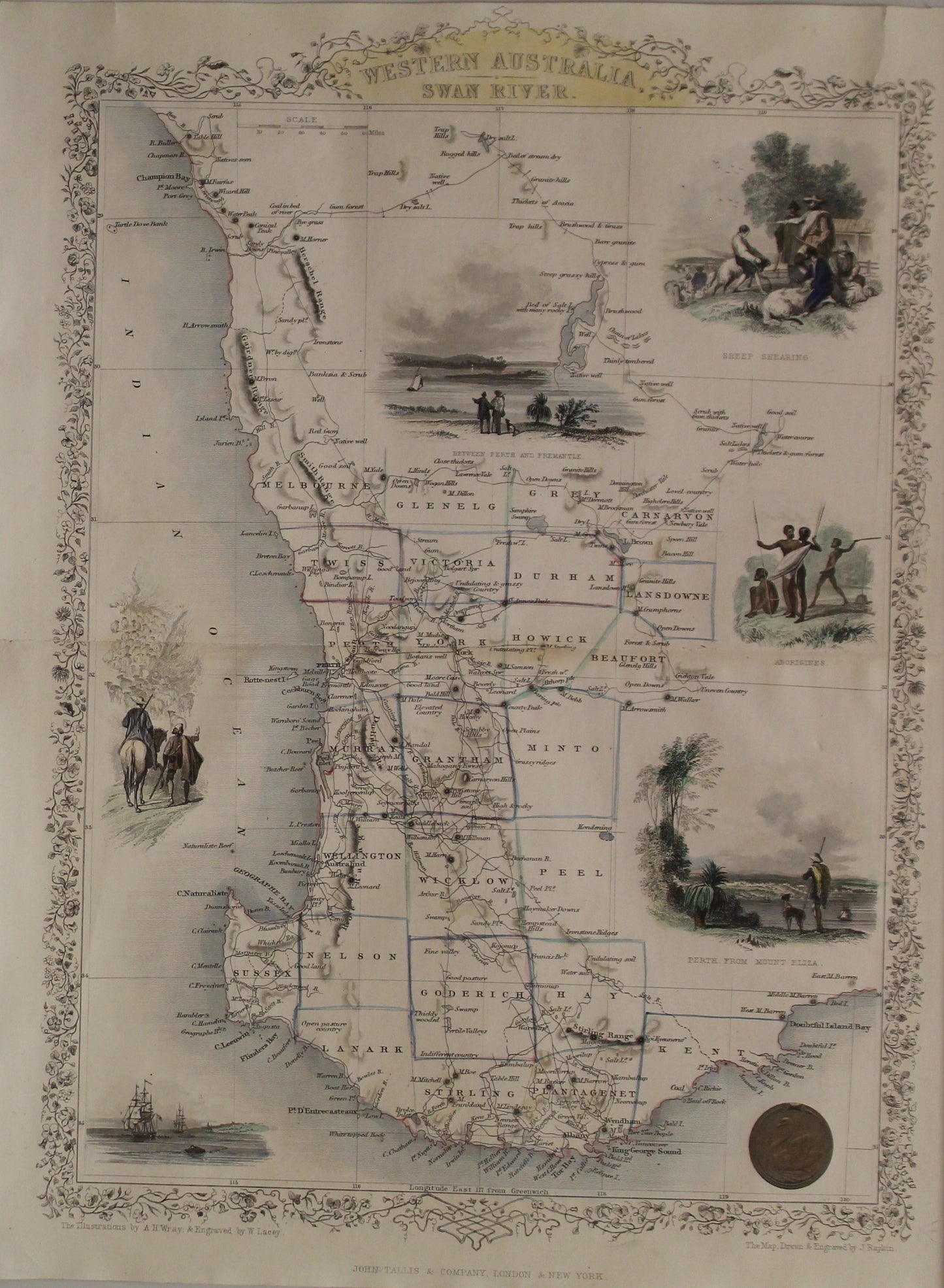
This is a scarce 1851 example of John Tallis and John Rapkin's 1851 map of Western Australia. It covers southwestern Western Australia from Champion Bay south around Sussex to Doubtful Island Bay. This map records the early settlements of the United Kingdom in the western part of Australia. It notes numerous counties, roadways, rivers, geographical features, and more.
Swan River is identified. The Swan River Colony including Perth was settled by the British in 1829. York, noted here, was the first inland settlement by the British in 1831. Albany with King George Sound, along with its surrounding areas is called Plantagenet, supposedly named so because King George, the reigning British monarch at the time, believed that he was related to the Plantagenet lineage of kings, who ruled many centuries earlier.
This map includes illustrations by A. H. Wray of Sheep Shearing, Aborigines, Perth from Mount Eliza and a view Between Perth and Fremantle. Illustrations of ships and natives is also included. The whole has the highly decorative presentation and elaborate border distinctive of Tallis maps. This map was issued as part of the 1851 edition of John Tallis and Company's The Illustrated Atlas, And Modern History of the World.
Biography
Tallis and Company published views, maps and Atlases in London from roughly 1838 to 1851. The principal works, expanding upon the earlier works of Cary and Arrowsmith, include an 1838 collection ofLondon Street Viewsand the 1849Illustrated Atlas of the World. His principal engraver was John Rapkin, whose name and decorative vignettes appear on most Tallis & Co. maps. Due to the decorative style of Rapkin's work, many regard Tallis maps as the last bastion of English decorative cartography in the 19th century. Though most Tallis maps were originally issued uncolored, it was not uncommon for 19th century libraries to commission colorists to "complete" the atlas. The London Printing and publishing Company of London and New York bought the rights for many Tallis maps in 1850 and continued Publishing hisIllustrated Atlas of the Worlduntil the mid 1850s. Specific Tallis maps later appeared in innumerable mid to late 19th century publications as illustrations and appendices.
Size W26cm x H36cm
SOURCE
Tallis, J.,The Illustrated Atlas, And Modern History Of The World Geographical, Political, Commercial & Statistical, 1851.